Snow load data · ND
Ground snow load in North Dakota
By Nivometra · Updated September 28, 2026
North Dakota’s snow history is recorded by 198 measurement stations in the federal ERDC/CRREL SR-20-1 dataset, with 5,495 station-years of observations at elevations from 790 to 2,980 ft. Across the 171 stations with a published 50-year value, estimates range from 16 to 79 psf, with a median of 35 psf.
- stations with a 50-year estimate
- 171
- median station estimate
- 35 psf
- highest station estimate
- 79 psf
Highest 50-year estimates in North Dakota
These are the stations with the highest 50-year ground snow load estimates in the state. Each value is a statistical estimate derived from that station’s snow record, not a measured load, and not a design value for any particular address.
| Station | Elevation | 50-yr estimate | Years of record |
|---|---|---|---|
| Forbes 9 Nnw | 2,030 ft | 79 psf | 34 |
| Grafton | 830 ft | 76 psf | 17 |
| Pembina | 790 ft | 69 psf | 28 |
| Selfridge 2 NE | 2,180 ft | 67 psf | 17 |
| Bisbee 6 NE | 1,600 ft | 63 psf | 26 |
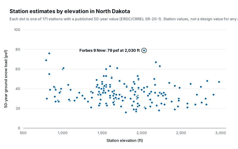
Even across North Dakota’s comparatively modest 2,190 ft elevation spread, estimated values vary from 16 to 79 psf. Local snow climate matters more than any single statewide figure.
What these numbers are
A 50-year ground snow load is the weight of snow on the ground, in pounds per square foot, with a 2% chance of being exceeded in any given year. It is the statistical basis of the ground snow load maps in ASCE 7-16 and earlier building codes, and the form of value their site-specific case studies call for. (ASCE 7-22 moved to strength-level values on a different basis; see what changed in ASCE 7-22.)
The values above are per-station estimates from SR-20-1, the ERDC/CRREL report federal agencies use for site-specific snow load analysis. Each is derived from the snow measurements at that station, so it describes the station’s location, not your address. Between stations, the defensible way to estimate a value is the SR-20-1 case-study method: take the surrounding stations, adjust for elevation, and interpolate.
Getting a value for a specific North Dakota address
If you own a building, your design snow load is set by your local building department; the guide on how much snow a roof can hold explains what the number means for an existing roof.
If you are designing one somewhere the map is coarse or marked for a ground snow load case study, Nivometra runs the SR-20-1 methodology for an exact location: it selects the relevant surrounding stations, shows you every one on the map with its elevation and record, and documents the interpolation in a report you can hand to a reviewer.
Ground snow load data for all states
This guide is educational content, not engineering advice. Structural decisions for a specific building should be made by a licensed engineer or your local building official.