Snow load data · NH
Ground snow load in New Hampshire
By Nivometra · Updated September 28, 2026
New Hampshire’s snow history is recorded by 181 measurement stations in the federal ERDC/CRREL SR-20-1 dataset, with 4,504 station-years of observations at elevations from 20 to 6,260 ft. Across the 155 stations with a published 50-year value, estimates range from 28 to 290 psf, with a median of 75 psf.
- stations with a 50-year estimate
- 155
- median station estimate
- 75 psf
- highest station estimate
- 290 psf
New Hampshire uses its own snow load study
The New Hampshire building code does not take ground snow loads from the national maps or from federal case-study methodology: it requires values from Ground Snow Loads for New Hampshire (US Army Corps of Engineers, ERDC/CRREL TR-02-6), which publishes a ground snow load for every city, town, and unincorporated township in the state. For a New Hampshire address, that study — confirmed with your local building department — is the number a reviewer will accept, so Nivometra does not generate reports for New Hampshire sites. The station data below is still the real snow record behind the state’s values, and useful context for understanding them.
Highest 50-year estimates in New Hampshire
These are the stations with the highest 50-year ground snow load estimates in the state. Each value is a statistical estimate derived from that station’s snow record, not a measured load, and not a design value for any particular address.
| Station | Elevation | 50-yr estimate | Years of record |
|---|---|---|---|
| Cannon Mountain | 4,000 ft | 290 psf | 20 |
| Cannon Mountain (Summit) | 4,000 ft | 219 psf | 22 |
| Pinkham Notch | 2,000 ft | 184 psf | 27 |
| Pontocook | 1,160 ft | 169 psf | 12 |
| Gorham | 790 ft | 147 psf | 31 |
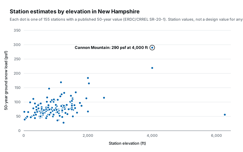
The spread is the point: New Hampshire’s stations span 6,240 ft of elevation, and ground snow load tracks elevation and local climate far more than state lines. A statewide figure, or a value borrowed from a station at a different elevation, can be off by a large factor in either direction.
What these numbers are
A 50-year ground snow load is the weight of snow on the ground, in pounds per square foot, with a 2% chance of being exceeded in any given year. It is the statistical basis of the ground snow load maps in ASCE 7-16 and earlier building codes, and the form of value their site-specific case studies call for. (ASCE 7-22 moved to strength-level values on a different basis; see what changed in ASCE 7-22.)
The values above are per-station estimates from SR-20-1, the ERDC/CRREL report federal agencies use for site-specific snow load analysis. Each is derived from the snow measurements at that station, so it describes the station’s location, not your address. Between stations, the defensible way to estimate a value is the SR-20-1 case-study method: take the surrounding stations, adjust for elevation, and interpolate.
Getting a value for a specific New Hampshire address
If you own a building, your design snow load is set by your local building department; the guide on how much snow a roof can hold explains what the number means for an existing roof.
If you are designing one, start from Ground Snow Loads for New Hampshire (US Army Corps of Engineers, ERDC/CRREL TR-02-6) — the New Hampshire building code takes its ground snow loads from that study, and your building department can confirm the value for your town.
Ground snow load data for all states
This guide is educational content, not engineering advice. Structural decisions for a specific building should be made by a licensed engineer or your local building official.